Researchers from the International Space Station (ISS) captured Hurricane Larry as it gathered wind and clouds over the Atlantic ocean.
Less than a week after Hurricane Ida ravaged North America, another storm has been spotted nearing the US. According to a USA Today report, Hurricane Larry is currently under Category 3 but is predicted to intensify to a Category 4 storm. If it sustains winds above 150 mph, it would become the strongest storm in the Atlantic this year.
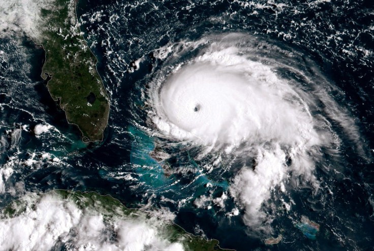
Using resources from spaces, researchers in the ISS monitored the hurricane's movement and size.
ISS Snaps Scary Photo of Hurricane Larry From Space!
Twitter user Megan McArthur, a NASA astronaut and veteran of Space Shuttle mission STS-125, tweeted a photo of Hurricane Larry. As seen in the image, the storm is massive, taking up a significant portion of Earth's atmosphere. Megan said she hopes this hurricane "doesn't make landfall."
Here is Hurricane Larry from @Space_Station yesterday. Hoping this one doesn’t make landfall. pic.twitter.com/I0PwrX858v
— Megan McArthur (@Astro_Megan) September 5, 2021
Arguably, the image of the hurricane is remarkable. It shows a striking swirl of wind and clouds with a highly concentrated center. The science is further emphasized in the second image, which features thick clouds that completely cover the view of the ground. This evidently proves the strong winds happening inside Hurricane Larry.
How to Track Hurricane Larry: Forecast and Path
Online tools are now available for anyone who wants to monitor the movement of this dangerous hurricane. The website Cyclocane, in particular, reports hurricane Larry's status with different reports.
At the time of writing, Hurricane Larry has a current wind speed of 125 mph and a max predicted wind speed of 125 mph, which might peak at Monday 11 AM.
Real-time radar loop readings warn about dangerous flashflood risks from Hurricane Larry. Ocean swells, life-threatening surf, and rip conditions might ravage the east coast of Atlantic Canada and the United States by midweek. Citizens in the area are recommended to avoid beaches for the duration.
Cyclocane also posted Hurricane Larry's live tracker and satellite image loop.
Hurricane Larry Weather: Prediction and Status
Sun Sentinel predicts Hurricane Larry to move closer to Bermuda later in its path. Using spaghetti models to forecast the storm, these are the predicted specific markers:
- Monday 8 PM - Wednesday 8 PM: Hurricane Larry would move in the north-west in the Atlantic Ocean
- Thursday 8 PM: Hurricane Larry would take a sharp turn going north-east, passing dangerously close to Canada
- Friday 8 PM: hurricane Larry would make another sharp turn back to the North Atlantic Ocean
Multiple online sources predict this trajectory for Hurricane Larry. However, its actual status remains to be observed.
ISS Has Busy Week With Hurricane Larry
The ISS recently tweeted a very busy week with their itinerary. Aside from its highlights of flying over a hurricane, the space laboratory received a SpaceX Dragon cargo, celebrated an astronaut's birthday, and showcased two cosmonauts in their spacewalk. A quick video of the events is embedded below.
The station flew over a hurricane, new science experiments were delivered on the @SpaceX #CargoDragon, an astronaut celebrated her birthday, and two cosmonauts went on a spacewalk this week on #SpaceToGround. pic.twitter.com/Xt4M6t3bnd
— International Space Station (@Space_Station) September 4, 2021


